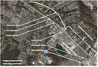
Crescent & Fox Pathway: access via Hyacinth


A bicycle route eastbound from LSU Campus would conveniently follow Hyacinth Avenue.  However, without turning left to ride on Perkins Road, there is an obstacle to proceeding east from Glasgow Avenue.  As shown in this sketch, there is no other connectivity across to Pollard Estates.  However, there are said to be gates and goat paths across the field there.  Suggestions of trails seem to be visible online, in this satellite view.  Future streets or pathways which might span that gap remain an uncertain aspect of plans for Rouzan development.
Hyacinth is an important bicycle route, offering good connectivity from S. Lakeshore, E. Lakeshore, and LSU Avenue, thus serving LSU Campus, residential neighborhoods, and apartment complexes in that area.  Hyacinth forms a straight run from its intersection with Stanford Avenue, across Lee Drive, to Glasgow.  There have been plans and even a bit of Federal funding, toward adding bike lanes along Hyacinth.  Years are passing and there has been no obvious start on the project, but construction would surely have to wait until the massive sewer overhauls (much needed and much overdue) are completed in that area.  The most recent news I found about Hyacinth bike lanes was in this article.

Crescent & Fox Pathway: navigating Stratford Place


Travelling east from College Drive can be tricky, but there is a way through, if you know it.  This sketch shows a route eastward from College Drive, without riding on Perkins Road.
The pictured area may be viewed in this online map, and exercise your map- reading skills.   Meandering through the Stratford Place subdivision appears deceptively easy on the map, but a missed turn in this neighborhood can require much riding in circles, trying to find your way out… some of us know!  Some cyclists like to use paper maps, others prefer GPS wayfinding.  Smartphones and their ilk could  search online for maps, or one could load map images into a cellphone for quick viewing.
You might have noticed that many areas of Baton Rouge lack contiguous grids of streets, some neighborhoods are cul de sacs, and streets sometimes change names or suddenly alter direction.  Unfortunately, despite the traffic snarls caused by these layouts and the hindrance of efficient emergency response, we are still making exceptions to the laws and disregarding the need for connectivity.

Crescent & Fox Pathway: Nairn Crossing

Click for larger view

Here is a connector route southeast from Midcity, which takes advantage of Nairn Street bridging across I- 10.   And, thank- you BREC and DPW, there is now a connector pathway crossing to Ferrett and Balis (behind the Wal- Mart).   Sharrow markings along the way are sometimes ignored by motorists; debris on the bridge and at the entrance to Nairn Park can be hazardous.  But it still seems better than riding on College or Perkins.  Please phone if you notice problems, to 311, or use their online reporting.
Bicycle travel in Baton Rouge can be challenging.  Some of us are not comfortable riding on arterial roads, so studying online maps and making paper printouts can help.  Saving images of map sections on the cellphone can make this navigation tactic even more convenient... just open the picture, rather than hoping for a signal and surfing the internet.   The Nairn Street map area may be viewed online here.

Crescent & Fox Pathway: the missing keystone


Click picture for closer view
We have been praying for rapid action of  state and local officials, dealing with the hazardous stretch of Perkins Road that has killed and maimed our friends and fellow cyclists. The lanes on Perkins Road are not wide enough for a bicycle and a car to share side- by- side. Automobile speed limits are posted as 45 mph, but if you drive 50, a stream of irate motorists will still pass you at breakneck speeds. The lane edges have drain grates and debris. Tall, perpendicular- faced curbs would limit the chances for a cyclist to escape danger by dodging off the roadway. Some have taken to bicycling in the center turn- lane, but that causes much confusion and consternation for the motorists. An online map and satellite views of the pictured area are available here.


A “Crescent  & Fox Memorial Pathway” through this Perkins Road corridor could provide the keystone link, interconnecting Moss Side, Pollard, Pennington Biomedical Research Center, Louisiana Department of Wildlife and Fisheries, Campus Federal Credit Union, Perkins Road Park, Kenilworth, and One Perkins Place. And, in the larger view, this would complete connections to serve a huge expanse of businesses, shopping malls, colleges, medical facilities, and residential neighborhoods which lie along adjoining neighborhood routes and within practical bicycle distances. It seems appropriate to associate Nathan’s Crescent & Fox artwork with a pathway, that it might be a tribute to him and others who have been killed or maimed on this segment of Perkins Road. Visit www.crescentand fox.com for a history of the logo, or for trust fund information.

Got events for the October Calendar?

We'll be happy to list your cycling events on the calendar... know of some happenings around the Baton Rouge area? Comment them here, send them online or drop a note by Midcity Bikes so we can include them.

Bicyclists' Writes: Cyclists Subsidize Motorists

Yep, we've heard it before, that cyclists should be kept off the roads, as they are not paying for them.  Well, this article from MoTown breaks it down, and shows that numbers get juggled and hidden costs are being conveniently ignored.  Quite the opposite case is made in this article, "Cyclists subsidize Motorists".

Crescent & Fox Memorial Pathway: a proposal

Perkins Road has again shown itself as a traffic danger to the Bike Community, and we have been trying to get this emergency recognized and resolved since October, when bicycle traffic increased greatly through that corridor. Meanwhile, our friend Nathan died there in January; and now Jason in September. The Perkins Road area where Nathan and Jason were killed constitutes a "keystone" in east- west bicycle routes. Without the means to safely ride through that corridor, it becomes a barrier to bicycle traffic.  And it blocks more than access to the sports- park complex! Routes to the Medical District, the Mall of Louisiana, all of North Baton Rouge, LSU, Midcity, and Downtown all interconnect through that corridor. Pennington Biomedical Research Center might become a key partner in resolving this situation if they are approached appropriately to seek their approval and resolve any legal and liability issues PBRC may have.  The quickest "fix" would be to cross PBRC property,which would of course, require meetings of  all other players with PBRC.  Beyond that, the simple matters of paint and publicity could be accomplished in short order.  We, the bike community, pray for state and local officials to meet with PBRC and seek their assistance to resolve this safety need for bicycle traffic.  Here's a link to some ideas:  definitely not a professional proposal, merely observations from a bicyclist's perspective.